Condors?!
Yes! This time we're going to explore the backcountry along the San Andreas
Fault east of San Luis Obispo.  Note
the new look to this page, if you'd visited earlier: Two separate check-out
trips had previously explored the Hi Mtn area east of Lake Lopez inland from
San Luis Obispo - the site of the tiny Hi
Mountain Condor Research Station and visitor center. The research station
is a volunteer labor of love by the biology and ecology
Note
the new look to this page, if you'd visited earlier: Two separate check-out
trips had previously explored the Hi Mtn area east of Lake Lopez inland from
San Luis Obispo - the site of the tiny Hi
Mountain Condor Research Station and visitor center. The research station
is a volunteer labor of love by the biology and ecology  students
of Cal Poly San Luis Obispo. There is a small family of condors which live and
forage in this vicinity of this rugged mountain range. However, the only campground
here I discovered to be completely unsuited for any astronomy. And, the road
to the research station is inacccessible this time of year due to high water
in the Salinas River (the dirt road has no bridge!). A second check-out by returning
student Ron Compton in January shows the other road to the condor lookout is
only suitable for 4WD.
students
of Cal Poly San Luis Obispo. There is a small family of condors which live and
forage in this vicinity of this rugged mountain range. However, the only campground
here I discovered to be completely unsuited for any astronomy. And, the road
to the research station is inacccessible this time of year due to high water
in the Salinas River (the dirt road has no bridge!). A second check-out by returning
student Ron Compton in January shows the other road to the condor lookout is
only suitable for 4WD.
 I've
decided the best choice is to stay in the more remote and geologically interesting
Carrizo
Plain National Monument, one mountain range east of the Hi Mtn.
area. Condors still forage
here, and in fact they often prefer to soar along the Caliente
Range where we'll be camping as the landscape is easier to spot meals on,
and there's less human contact. With luck, we may watch these huge birds gliding
the late afternoon thermals. Carrizo Plain is one of my all-time favorite places,
especially
in the springtime. It has inspired poetry,
and painting.
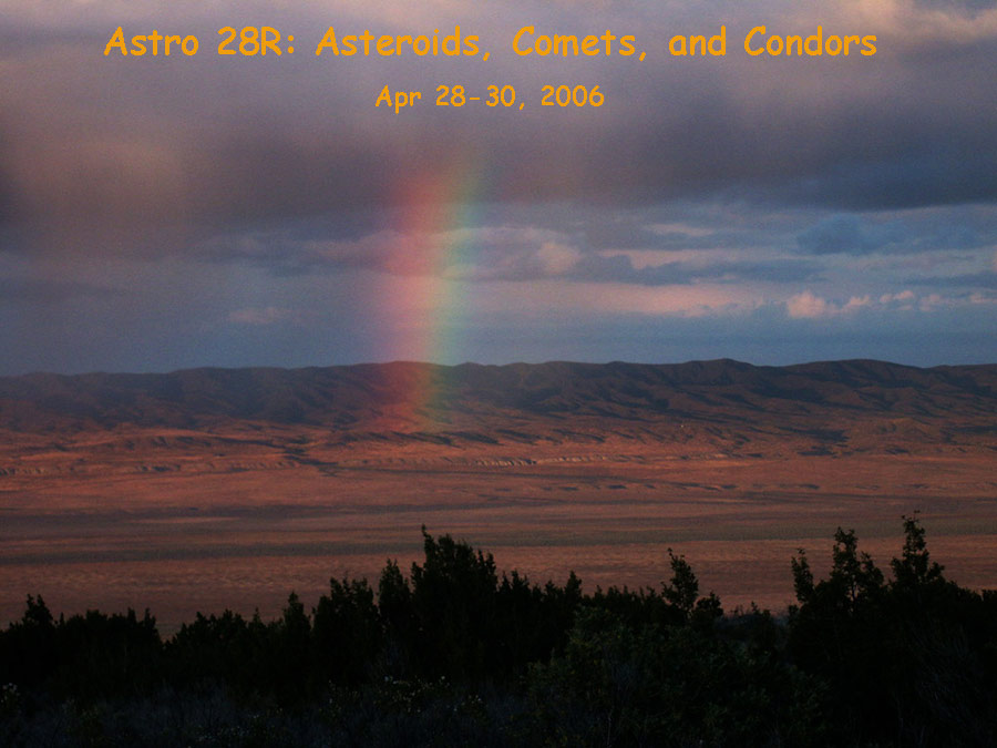
The title picture at top shows a rainbow over the valley with the San Andreas
fault scarp in the distance, as photographed from our campsite. The picture
below it, at left is also shot from our campsite. Ancient home of the Chumash
Indians and sacred Painted Rock (with painting dating back 3,000 years), home
to many rare and endangered species as the last large tract of native California
valley ecosystem, Carrizo Plain was bought by the Nature Conservancy and converted
to a National Monument in 2001 as one of President Clinton's last official acts.
It was created not so much for vacationers (accomodations are minimal), but
for the preservation of the native plants and animals. The most dramatic stretch
of the entire San Andreas Fault is also here, with huge offsets in stream channels
from the Great
Quake of 1857. On Saturday we'll explore the geologic history of the Plain
and how it's unique landforms were created, including Soda Lake and Wallace
Creek. We'll camp among the scrub oak of the Caliente Range, with panoramic
views of the 50 mile long basin and its geologic features.
I've
decided the best choice is to stay in the more remote and geologically interesting
Carrizo
Plain National Monument, one mountain range east of the Hi Mtn.
area. Condors still forage
here, and in fact they often prefer to soar along the Caliente
Range where we'll be camping as the landscape is easier to spot meals on,
and there's less human contact. With luck, we may watch these huge birds gliding
the late afternoon thermals. Carrizo Plain is one of my all-time favorite places,
especially
in the springtime. It has inspired poetry,
and painting.
The title picture at top shows a rainbow over the valley with the San Andreas
fault scarp in the distance, as photographed from our campsite. The picture
below it, at left is also shot from our campsite. Ancient home of the Chumash
Indians and sacred Painted Rock (with painting dating back 3,000 years), home
to many rare and endangered species as the last large tract of native California
valley ecosystem, Carrizo Plain was bought by the Nature Conservancy and converted
to a National Monument in 2001 as one of President Clinton's last official acts.
It was created not so much for vacationers (accomodations are minimal), but
for the preservation of the native plants and animals. The most dramatic stretch
of the entire San Andreas Fault is also here, with huge offsets in stream channels
from the Great
Quake of 1857. On Saturday we'll explore the geologic history of the Plain
and how it's unique landforms were created, including Soda Lake and Wallace
Creek. We'll camp among the scrub oak of the Caliente Range, with panoramic
views of the 50 mile long basin and its geologic features.
Carrizo Plain was the site of our Astro 28K field course, and you can enjoy many pictures at this post-trip highlights link.
Astronomical Highlights - Comet Schwassman-Wachmann 3
We have three special events to focus on. First, this is the peak weekend for the passage of Comet Schwassman-Wachmann 3 by the earth. Comets are giant dirty snowballs (or icy dirtballs??) and gradually melt like the wicked-witch-of-the-west with each passage by the sun. Comet SW3 broke into 3 pieces in its last passage by the sun, exposing fresh snowy surfaces and increasing the outgassing significantly. The main component is predicted to get as bright as 4th magnitude in early May as it passes the earth high in the eastern evening sky. This is ideally placed for us, high in the sky. Comets, though, are like cats - they both have tails and they both do exactly what they want. No prediction is safe, and we'll just have to see what happens. Could the comet start a final spectacular dissolution? Will the fresh surfaces be caked over with dirt and make it fainter? Will we be able to see the two fainter pieces, which non-gravitational forces have pushed farther from the main fragment over the past few years? The comet will be passing through Hercules and close to the great globular cluster M13 this weekend.
Astronomical Highlights - Two Bright Asteroid Occultations
First, Friday evening at 12:36am the 81 mile diameter asteroid Zelinda occults a bright 7.6 magnitude star along a wide path. Currently, the predicted path's northern limit skims along the California coast from Big Sur down past the Lompoc area. This puts us close to the northern limit so our odds of getting the event are about 50/50. The star is bright enough that we should be able to monitor it even in tripod-mounted binoculars so all can get data. I will be videorecording the event and showing it live on a TV monitor for play-back. The altitude is low; only 9 degrees up in south. Our mountain top elevation will be perfect. Zelinda is large enough that it may well have a small moon or two, as increasing numbers of asteroids are being discovered to have. If so, we have a chance of getting an occultation even if the main path misses us. The calculated path will probably move a bit as we get close to our weekend. With luck, it'll shift into our direction.
Next, on Saturday night (also just past midnight - 12:28am) the asteroid Selene occults a 9.5 magnitude star from a 30 mile wide path which crosses right over us: entering California at Montana de Oro State Park and continuing on to the east southeast through Carrizo Plain and Bakersfield. This is a relatively bright star and will show well in our telescopes, at 47 degrees altitude. This is a remarkable opportunity - two bright stars occulted by large asteroids, paths criss-crossing on a weekend. We can probably expect that there will be other observers from the LA and SF Bay areas helping get data on these events. Here you'll find a Google Earth map of the path. By the way, you can also zoom in (click "satellite") and get a very detailed look at our campsite, using the topozone.com link below to guide you.
Earlier in both evenings, we'll have our telescopes out and study the star fields of the Milky Way in Gemini, and the galaxies of the Virgo Cluster area. We'll make a special trip up to the top of Caliente Peak late on Friday night to try for the Zelinda occultation, and also try to spot the most beautiful globular cluster in the heavens - the great Omega Centauri cluster, which rises at most only very low in the south, transiting at 12:00am at 8 degrees altitude these late these April evenings.
Day Explorations
During the day the theme will be geologic studies tied in to the evolution of the inner planets. After I cook up my standard delicious breakfast of French crepes, we'll migrate down the mountain and explore Soda Lake, Painted Rock, and then on to Wallace Creek and the San Andreas Fault trace, following it along scarps, dry sag ponds, and offset ridges and channels. Sunday will begin with breakfast, then explorations along Bitterwater Rd northward through a bizarre landscape shaped by the San Andreas Fault as it transitions from the sticky zone near the transverse ranges to our south, to the straight section characterized by creep and smaller quakes, past ancient barns, backcountry small vinyards and open range, and finally crossing Hwy 46 and northward into Parkfield. - self-proclaimed "Earthquake capital of the world" - and we'll look at some of the earthquake sensors arrayed here, as well as evidence of the slow creep that characterizes this section of the fault. Then brunch at the historic old Parkfield Inn, a favorite stopover for bikers.
My friend and fellow photographer Dave Wyman has many fine images from Carrizo Plain - it's a beautiful place, especially in the Spring. Start exploring his images here. My own trips to Carrizo Plain are photo-recorded here, here, here, and here. Another nice site with plenty of spring wildflower images is here.
Registering for the Class.
After one semester trying something different, we're going back to the standard procedure we've always had. Click here to read more on this.
On-Campus First Meeting, and a Bit About Our Campsite
We'll meet at the planetarium - room 706a - on Wednesday Apr 26 at 5pm (note, it says 4:30pm in the schedule of classes). At this session, I'll hand out maps to the campsite, itineraries, what to bring, and we'll help you with carpooling. Then, we'll have slides and a planetarium show discussing comets, asteroids, solar system formation and evolution. We'll probably be done by 7:30pm. Note that this site is a wilderness site and we'll have extra needs for portable tables and for water. Also, we will want to minimize waste as there's no dumpster nearby. Plan to bring your own non-disposable plates and silverware, and water. Any portable tables will help. I've got two (a medium and a small) I will bring from the observatory. Our campsite has a great view and is much more attractive than the official campground. The official campground has only 6 sites anyway, and has a poor view of the sky and the Plain. Still, it does have port'o potties and some wash water if we need it. It's only a mile downhill from our camp site.
Itinerary
Friday we'll arrive at camp and you can pick a nice spot amongst the hillside mini-trees for your personal home-away-from-home. We'll set up the kitchen and the scopes and Ron and I will fix you an Asian-theme moo shu w/ rice dinner, with your help. At dark, we'll begin our explorations of the night sky and study of the comet especially. As we get closer to 11pm, I would like to bring the 8" scope up to the top of the mountain; another 15 minute drive upward. From there, we can have a flat 360 degree horizon and a beautiful view of two key things - the Omega Centauri globular cluster, which never gets high enough to see from Santa Cruz (it's by far the biggest and most spectacular of the Galaxy's globular clusters), and the Zelinda asteroid occultation at 12:30am, which is only 7 degrees above the southern horizon.
Saturday we start with a crepes breakfast. Then head down to the Goodwin Visitor's Center where we'll learn more about the wildlife at the plains, and get permission to enter the sacred Chumash Indian site Painted Rock. It's a half mile walk from the parking lot, which itself is a mile drive from the Visitor Center past a locked gate. I'll mountain bike it. We'll study the paintings and enjoy the only shade in Carrizo. Then, we'll head across to the lookout on the hill above Soda Lake and have our first geology talk. Then take the road out to and adjacent to Soda Lake where we'll stop and investigate this unique lake - not quite wetland, and not quite desert playa. Then continue on to Wallace Creek where there is a particularly dramatic examples of offset streams and one can see the exact fault trace of the San Andreas. We'll drive along the fault for a while, enjoying the wildflowers and taking photographs, then circle back around to the main Soda Lake road and eventually back to camp. Saturday night is more astronomy and astrophotography from camp, w/o the hilltop journey. At 12:30am we'll have our second asteroid occultation attempt.
Sunday morning I'll help fix you a granola and eggs breakfast, and then pack up camp and begin our San Andreas Fault study in earnest. We'll drive north to Bitterwater Road, which is a beautiful rural 1-lane pave road all the way up to Hwy 46 following the trace of the San Andreas Fault. We can study sag ponds, slope failures, offset streams, and the strange topography that typifies a continuously moving fault zone. There'll also be photo stops for flowers and old barns. We'll emerge at Hwy 46 near Parkfield, and go to visit some of the instrumentation along the fault, and have lunch at the historic Parkfield Inn where I'll distribute the take-home final exams. From here, you can either backtrack to Hwy 46, or follow me and head over the mountain to link up with Hwy 101 just north of San Miguel. Wildflowers should be spectacular after our wet winter.
Get on Hwy 101 and drive south to Paso Robles. IMPORTANT! This is a MANDATORY gas stop! This is the last gas station you'll see until your return drive through Paso Robles on Sunday - that's a bit over 200 miles roundtrip. So whether you need it or not, get gas here now. Then head east 16 miles on Hwy 46 to Shandon. At the Shandon turnoff, go into the little town and turn right (south) on Truesdale Rd. Stay on it heading south and it'll join with Shell Creek Rd, which you continue on for another 15 miles or so until it hits and ends at Hwy 58. Go left (east) until you enter Carrizo Plain (you'll see signs for "Carrisa Plain" and "Carissa Fellowship Church") and it'll be obvious you're out of the hill country and in the plains. Turn right onto Soda Lake Road, where there's a sign for "Carrizo Plain National Monument". Drive south through the sparse community of California Valley and into the National Monument, past Soda Lake and note the dirt road to the Goodwin Education Center (park visitor center) on your right. 1 mile after Goodwin you'll see a sign "Selby Camp/Caliente Ridge". Turn right onto this dirt road and drive about 4 miles, into the Caliente Range foothills and you'll come to a fork in the road right where there's an old abandoned ranch. To your left will be "Selby Camp". You will stay to the right -"Caliente Ridge" and go through an open gate. Note your odometer! You now go precisely 1.15 miles up this road winding into the mountains and you'll come to a fairly flat area with parking and we'll be right there. Here's a link to the topozone.com topographic map of our campsite - Camp is the "x" in the middle. Play with Topozone's controls to see a wider view and how the dirt road to camp looks. We're not in a campground, so bring your own water and pack it in/pack it out!