Astro 28K: Field Astronomy at Carrizo Plain National
Monument
Mar 23-25, 2012
Post Trip Photos
This class will focus on planetary science: the unique plate tectonic geology of this newest National Monument in California, measuring the size of the asteroid Heidelberga, and
put everything into an astronomical context. The San Andreas fault zone has created
a wide, semi-desert valley which harbors one of the last large tracts of rare
native plants and animal ecologies in California. Because of this, the Nature
Conservancy and the National Park Service bought this land and preserved it,
primarily for the endangered species and not for visitors - perfect for crowd-shy
astronomers.
 Carrizo
Plain National Monument is most famous for those pictures you've probably seen
of dramatically offset creeks and drainage due to the San Andreas Fault.
 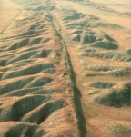 It
also has spectacular wildflower displays in late March and early April. Soda
Lake, an alkali lake created by uplift due to the fault, has surrounding
marshlands and abundant rare and native wildlife. There are few trees and horizons
are good. Carrizo provides a good setting to demonstrate and discuss crustal
processes common to the inner planets as the area is a graben formed by the
actions of the San Andreas Fault; one of the great tectonic plate boundaries
on our planet.
The beauty of this land, especially in the spring time, has inspired both ancient
peoples of the Chumash tribe, who left fascinating inscriptions at Painted Rock
Sacred Site near our camp, as well as modern
poetry which is at the Carrizo Plain National Monument website. Learn more about the Chumash inscriptions here.
My friend and photo workshop colleague Dave Wyman took incredible images during
his photo workshop
here in the Spring of '03, including the image at upper left.
On-Line Links for Carrizo, and Past Astro 28's to Carrizo
Learn more about this little known treasure of California here,
and here,
and at the Sierra Club's page here.
A geologic tour can be found
here. Dave Wyman's Image Quest photo workshops have produced
some beautiful images from Carrizo Plain, which is also one of the great wildflower photography locations each Spring, seen here.
We have had past Astro 28 Field Astronomy classes conducted at Carrizo Plain, using the same campsite I plan for the 2012 trip. See the photo pages for the 2004 trip here, and the Spring 2006 trip here, and the Spring 2008 trip here.
Astronomical Highlights
 The asteroid Heidelberga will occult a faint 12.2 magnitude star in Leo late Saturday night at 2:15am from a path about 96 miles wide, which crosses over most of Carrizo Plain National Monument. The track is shown at left. Our campsite is shown as the red circle. Inside this path, observers will see the star wink out for up to 7 seconds, then wink back on. Making precise time-stamped GPS video recording of the event and combining these for different observers throughout southern California (note the path cuts across the astronomer-dense L.A. area) will allow a precise measurement of the size and shape of Heidelberga. Such measurements have now been done for several hundred asteroids by amateur astronomers such as ourselves, contributing to our understanding of the formation and evolution of these objects. We will have the necessary GPS-time-stamped video capability and with good weather, should make an important contribution.
Late March is also the perfect time to study the star formation regions of the Orion spiral arm - our home in the Milky Way Galaxy. We'll study star clusters, emission and reflection nebulae, planetary nebulae, and on Saturday evening study galaxies and cosmology as well.
And finally, Comet Garradd will be at it's brightest high in the northern sky of the evening sky - just off the Big Dipper, near 6-7th magnitude in brightness and easy to study. It will be fresh from it's perihelion passage by the sun and should have a nice tail which we can see in binoculars and photograph with our gear - the same gear which has produced the dramatic student photography of Astro 9.
Planetary Science Studies During our Day Hikes
Shortly after dawn early risers are welcome to join me for an optional session
of landscape photography from camp. Early morning light on Soda Lake, 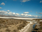 the
dramatic Temblor Mountain range across the plain, and macro photography of native
grasses and wildflowers in morning light should make for beautiful images. At 8am I will cook
up one of my famous crepe breakfasts
for the crew, we'll examine the sun using our solar filter. Then we'll go to the Visitor's Center to learn more about the Plains and get
a guided access to the trail to Painted Rock - one of the most impressive and interesting Native American sacred sites in all of the Southwest. We'll then take geologic
study walks to explore Soda Lake, Wallace Creek and the offset stream beds and surface traces of the San Andreas
Fault, calculating creep rates and relating to
the fault at Pinnacles National Monument. We'll have many short lectures and lecture handouts along the way, describing the formation of the inner planets, the conditions necessary for plate tectonics to happen and how unique the Earth is. We'll describe plate boundary types, and visit the San Andreas Fault which is the most dramatic strike-slip fault on our planet, and the most spectacular trace of the fault is right here in Carrizo Plain.
the
dramatic Temblor Mountain range across the plain, and macro photography of native
grasses and wildflowers in morning light should make for beautiful images. At 8am I will cook
up one of my famous crepe breakfasts
for the crew, we'll examine the sun using our solar filter. Then we'll go to the Visitor's Center to learn more about the Plains and get
a guided access to the trail to Painted Rock - one of the most impressive and interesting Native American sacred sites in all of the Southwest. We'll then take geologic
study walks to explore Soda Lake, Wallace Creek and the offset stream beds and surface traces of the San Andreas
Fault, calculating creep rates and relating to
the fault at Pinnacles National Monument. We'll have many short lectures and lecture handouts along the way, describing the formation of the inner planets, the conditions necessary for plate tectonics to happen and how unique the Earth is. We'll describe plate boundary types, and visit the San Andreas Fault which is the most dramatic strike-slip fault on our planet, and the most spectacular trace of the fault is right here in Carrizo Plain.
We'll also search for evidence of the possible comet impact which struck North America 12,900 years ago, at the end of the last Ice Age, creating a carbon-rich layer at several locations, including California (the Channel Islands) and Arizona. I know of no discovery of this layer on mainland California, but the ancient Pleistocene lake larger than, and in about the same place as, Soda Lake, would be an excellent depositional environment to find such a layer. Read more about the evidence for the impact in the this paper (Firestone etal 2007) , Firestone other related papers , and perform your own web searches.
 The Selby Rocks are close to our planned campsite.
Camping
In order to see the Comet Garradd and have good horizons we will not be camping in
either of the two primitive campgrounds in the park. Instead, we will be camping
on BLM land in the Caliente Mountains with wide views of the plains and the Temblor
Range across the plains. It's a beautiful spot which has magnificent views. You can see it in our prior Carrizo Plain Astro 28 trips Post-Trip photo page images. Our site has no facilities - it's just a beautiful patch of native California ridge land covered with small trees and wildflowers - it's as wilderness as it comes. (and free!) Plan to bring your own water as there will be none
at our campsite. We'll bring tables from the observatory, but you should bring beach
chairs and if you have small roll-up tables, bring them. Bathroom facilities and water will be 2 miles away at Selby Camp, but of course there
are plenty of bushes for the adventurous. Here's a list of camping items you'll need to bring. Especially for this wild location, be sure to bring a folding beach chair as there's no campground tables, benches etc! If you don't have your own chair, you'll be sitting on the (damp?) ground.
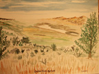
Photos (and this watercolor by yours truly) from an early check-out trip.
In the painting, made from our campsite, I'm looking down on Soda Lake from our campsite. Here are photos
from an early checkout trip...at Soda Lake nature walk, and another
view and, here is the view from our campsite looking towards Soda Lake.at Soda Overlook looking
towards the Caliente Range.
5,200 ft Caliente Peak is the highest peak in this picture. In the late afternoon a final rain shower produced a beautiful
rainbow in this picture and here, taken from our campsite. Note the San Andreas
Fault scarp catching the setting sun's rays across the middle of this picture.
We'll be exploring the scarp on Saturday. Weather in late March can be beautiful. Or rainy. Carrizo Plain is pretty dry, normally. Much less rain falls here than in Santa Cruz. But if it is raining, we'll set up our kitchen under the big flex canopy I have. Bring rain flys for your tents.
Directions to camp. Get on Hwy 101 and drive south
to Paso Robles. IMPORTANT! This is a MANDATORY gas stop! This is the last gas
station you'll see until your return drive through Paso Robles on Sunday - that's
a bit over 200 miles roundtrip. So whether you need it or not, get gas here
now. Then head east 16 miles on Hwy 46 to Shandon. At the Shandon turnoff, go
into the little town and turn right (south) on Truesdale Rd. Stay on it heading
south and it'll join with Shell Creek Rd, which you continue on for another
15 miles or so until it hits and ends at Hwy 58. Go left (east) until you enter
Carrizo Plain (you'll see signs for "Carrisa Plain" and "Carissa
Fellowship Church") and it'll be obvious you're out of the hill country
and in the plains. Turn right onto Soda Lake Road, where there's a sign for
"Carrizo Plain National Monument". Drive south through the sparse
community of California Valley and into the National Monument, past Soda Lake
and note the dirt road to the Goodwin Education Center (park visitor center)
on your right. 1 mile after Goodwin you'll see a sign "Selby Camp/Caliente
Ridge". Turn right onto this dirt road and drive about 4 miles, into the
Caliente Range foothills and you'll come to a fork in the road right where there's
an old abandoned ranch. To your left will be "Selby Camp". You will
stay to the right, following the directions to "Caliente Ridge" and go through an open gate. Note
your odometer at the gate! You now go precisely 1.15 miles up this road winding into the
hills and you'll come to a fairly flat area with parking on the right side - That's camp. The coordinates are: Longitude 119.8539 deg, Latitude 35.13056 deg. I'll be there
by about 6pm. Some students might get there earlier. Soon I'll have a graphic showing exactly where our campsite is, and post it in the box below.
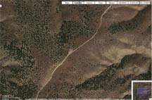
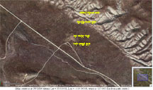
Google Earth view of our campsite, at center of image. Note the clearing for parking. We have a panoramic view down to Painted Rock and Soda Lake. It'll be open, green grassland with some tent-sized trees and bushes.
|
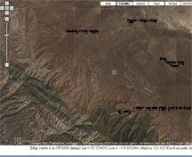
Larger view of the few miles around our campsite, and directions off the main road
|
Here's some locations we will want to explore during the day...
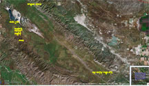
Most of Carrizo Plain National Monument, with key sites labelled, from Google Earth. See below for up close versions of our sites |
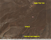
Goodwin Center, where we begin a guided tour (I hope) through locked gate, to parking lot and then a 3/4 mile hike to Painted Rock
|
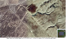
Wallace Creek, a dramatic offset stream bed on the San Andreas Fault
|

Soda Lake, which will be mostly dry alkali with wildflowers along the berms. Access road is at bottom
|

On Sunday morning, we stop here for another mini-lecture, and walk out to the lake as well.
|
San Andreas Fault, beheaded streams, and bizarre rock assortments here, ~12 miles south of camp turnoff
|
|
We're not staying in a campground, so bring your own water and pack it in/pack
it out! I'll bring some water for cleaning dishes, and for group meal cooking only.
Latest Update: Monday eve March 19
Weather for Fri-Sun on Mar 23-25: Cool, partly cloudy Fri and Saturday. Highs about 65F, lows about 45F. Later on Sunday, 25% chance of showers. We'll be heading back home around mid-day and so we may hit some showers on the way home. This area generally gets little rain; it's semi-desert. If we have too many clouds at night, we'll stoke the campfire and I'll talk to you about the Birth of the Universe and lots of very cool stuff! We'll want firewood volunteers for sure on this one.
Latest Update: Wed eve Mar 21
Weather forecast is now 60% chance of rain on Saturday late afternoon and night, into Sunday. Breezy as well. I've sent out an email to all students, asking if they'd like to postpone the trip for one week, till the March 30/Apr 1 weekend when it is possible the weather will be better (but it does appear we're in a pattern of repeated storm systems "for the next 10 days".). Only if all students say yes, will I consider doing so, based on the weather forecasts on Thursday march 22. I'll then email everyone with a final decision on the date for our class.
 Carrizo
Plain National Monument is most famous for those pictures you've probably seen
of dramatically offset creeks and drainage due to the San Andreas Fault.
  It
also has spectacular wildflower displays in late March and early April. Soda
Lake, an alkali lake created by uplift due to the fault, has surrounding
marshlands and abundant rare and native wildlife. There are few trees and horizons
are good. Carrizo provides a good setting to demonstrate and discuss crustal
processes common to the inner planets as the area is a graben formed by the
actions of the San Andreas Fault; one of the great tectonic plate boundaries
on our planet.

 The Selby Rocks are close to our planned campsite.


