 This
class is in the early planning stages. The idea is to build this course around
the observation of a lunar grazing occultation of a star by the last quarter
moon, along a path which crosses the northern peninsula of the park.
An excellent stop on the next Pt. Reyes Class: Sunset Rocks, near Jenner. They are favorite climbing rocks, are metamophic and tell the fault story well, and most interesting, they are polished by giant Wooley Mammmoths. Here's one web reference
 This
class is in the early planning stages. The idea is to build this course around
the observation of a lunar grazing occultation of a star by the last quarter
moon, along a path which crosses the northern peninsula of the park.
The Setting
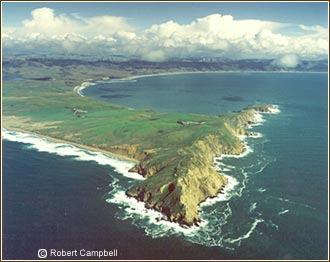
Pt. Reyes National Seashore is one of my favorite places anywhere. It is a bit of land originating in the far south tropics on the Pacific Plate. It has been transported up along the California coast by the action of the San Andreas Fault, which runs along the coastline in this section of California. The fault runs underneath the narrow Tomales Bay and the different geologies on either side of the fault will make for interesting explorations. We'll also explore the tide lands and what I consider the tastiest oyster farm in California - Johnson Oyster Farm - inside the park along the main lagoon. The Pt. Reyes headlands show facinating rock strata and have a unique geological story which we'll explore. A "live" webcam shows the current view of the sky and coast at Pt. Reyes.
Camping
I haven't decided where we'll camp. Ideally, I'd like to camp up on Mt. Vision, which has panoramic views of the park and is high enough to be above any coastal fog at this time. We might also consider the AYH hostel, which is in a valley with an environmental education center. I'll look into that. There are no drive-in group camp spots on the peninsula, although there are other campgrounds near by.
The Graze
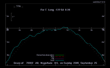
On Sunday morning at 4:31am an 8.5 magnitude star will graze the northern dark
limb of the last quarter moon high in the sky. As it grazes the edge, we'll
videorecord the star as it disappears and reappears along the mountains and
canyons silhouetted against the sky. These are beautiful events to watch and also are scientifically valuable as
they give us the best means we have of precisely measuring the latitude coordinate
of the moon's orbit. The profile of the edge of the moon is shown at right.
The graze will be best seen from this spot along the northern peninsula road,
shown here.
Check back later as the planning gets further along...
Update
I'm keeping options open, given uncertain weather and camping availability.. This same Sunday morning there is another, brighter grazing occultation in the Los Padres National Forest east of San Luis Obispo. The graze star is 7.6 magnitude. The graze path goes from just south of Montana de Oro State Park on the coast, through San Luis Obispo, and into the Los Padres National Forest to the north east. North of Lopez Lake is Hi Mountain Lookout, where a condor research station has been established by Cal Poly, with a small visitor center. Hi Mountain is a 3,000 ft mountain with a campground on the north side of the ridge. Unfortunately, the prime southwestern horizon looks to be blocked by Hi Mountain itself. Better for astronomy would be Navajo Flats, site of the Central Coast Astronomical Society's dark site excursions. But there's no campground here, and pretty dry and shade-less in September. Stay tuned... I'm still investigating. Here's a page I put together after my scouting trip to Point Reyes Christmas eve '04.
Latest Update: The Pt. Reyes people were not very hospitable about letting us stay overnight for our graze or any observing. They apparently really don't like people staying in the National Park here. Too bad, as this is an excellent place for an educational class. The person I talked to was in charge of special permits, and made no effort to be helpful, actually. Very much in the small bureaucrat mold.
I'm now considering a trip to one of the hot springs areas of the Sierra's, similar to our Astro 28E trip, or possible another version of the Mt. Lassen Astro 28H trip. Check back later in January '05 to see what I can come up with...