The Occultation of a 12.4 Star by Asteroid 2001-SK107
June 15, 2023 at 11:03:45pm
This is a low rank event, but our observations could significantly improve the orbit. There are 5 observers signed up, including me, Kirk, and Karl. We're apread enough we have a decent chance someone or more will get it. It's at 11:03pm, not an unreasonable time of night. It's in a dense region of Sagittarius, about a degree or two left of the Trifid Nebula, above the top of the Teapot star. It's at 18 degrees altitude, Az=140 in the SE. The star is bright enough at 12.4 that we may get away with 8x or even 4x if it's really clear. No moon to worry about. The event only lasts 1 second so try not to over-do it on integration or it might not pass the false positive test. Give yourself some time to ID the star field, there's a LOT of stars. I'd recommend raising the integration high while you're trying to ID the field on the chip
Fog is a question mark. There looks like a front that passed through on the map, but that's good, it tends to mean the inverson layer is mixed out. The prediction is for only patchy fog after 11pm so we might be OK. I will plan to try it from Rodeo Gulch if Kirk will try it from home. Oir Kirk tries it from Bonny Doon, please let me know where you'll be so I can avoid your track. The fog layer this early a.m. in Oaksland extended upl to 2150 ft, but it might be gone now. I can't seem to bring up the usual detailed wordy forecast talking about fronts and high and low pressure. That link is dead.
We'll take a look about 9:15pm to see where the clouds are and I'll email again any change of plans. 18 deg altitude is probably doable from my driveway if it's really clear, and that's a tempting location too, if Kirk wants to get higher up.

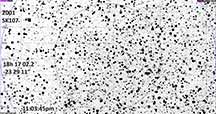
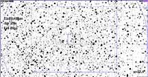
The target star doesn't seem to be in the UCAC4 catalog. The star which is very close and has the cross almost on it, is a 14.2 star. The target star will be much brighter than that. The 14.2 will mean that we will have to be careful to probably insure we include it in the reduction aperture. |

Target star is not shown, but the nearby 14.2 mag star is shown and it is only about 3" away from the target. VERY close in our scopes. |
|
|
Results:
My first interpretation of the cloud changes on the satellite maps was that a front had passed and that we'd have clear skies, or at least clear above patchy fog. That was also the NOAA prediction. So I made the charts, packed the RAV4 and then kep up on the weather maps... alas, the fog rolled in with a vengeance and kept climbing right up to the moment of go/no-go decision. At that moment, the satellite images showed the fog had covered the very top of Bonny Doon, barely. So for low altitude like this one, it says "cloud out". I bailed at the last minute. Karl had fog roll in early and cover his place at 1600 ft. But the maps showed even up to 2600 ft it was going to be clouded out. I could not find a location at 2600 ft at the top of BD that would have the required horizon and parking space.
Kirk Bender
Drove to the BD Eco Preserve, it was cloudy, so the plan was for him to drive to Sunlit Lane, thinking I'd continue on to 2150 ft elevation at Locatelli meadow. But at Sunlit lane, the fog was licking at the airfield, and stars overhead were visible, but at 18 degrees altitude it was too foggy, and that got worse as the event time approached. Clouded out, a doomed, but valiant effort.

