Christmas in Virgo - Graze Adventure 2005
Christmas weekend 2005 features the waning moon grazing the two brightest stars
in Virgo. I'm planning a road trip to videorecord both of these events. Along
the way, I'll enjoy coastal northern California and Oregon for photography,
some watercolor painting, and perhaps some fishing or seafood foraging, staying
at hostels along the way.
Beta Virginis
 On
Thursday evening Dec 22 just after midnight the last quarter moon grazes Beta
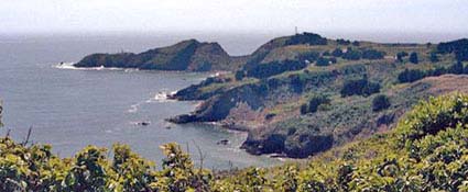
Virginis along an east-west path passing through Marin Headlands National Recreation
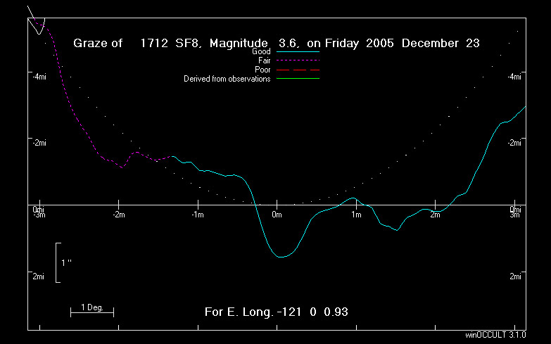
Area. Here is the prediction sheet. The altitude
is low - only 5 degrees - but a 3.6 magnitude star will burn through that haze,
especially with a bit of elevation to help. I'm planning on staying at the Golden
Gate Hostel, which is on Rodeo Lagoon and close to the graze path. Here's
more on the hostel.
To get a clear view to the east where the moon will rise just before the graze,
I'll need to get atop one of the many nearby hills. The profile shows two good
tracks which promise many events.
On
Thursday evening Dec 22 just after midnight the last quarter moon grazes Beta
Virginis along an east-west path passing through Marin Headlands National Recreation
Area. Here is the prediction sheet. The altitude
is low - only 5 degrees - but a 3.6 magnitude star will burn through that haze,
especially with a bit of elevation to help. I'm planning on staying at the Golden
Gate Hostel, which is on Rodeo Lagoon and close to the graze path. Here's
more on the hostel.
To get a clear view to the east where the moon will rise just before the graze,
I'll need to get atop one of the many nearby hills. The profile shows two good
tracks which promise many events. 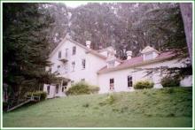 Because
the cusp angle is only 5 degrees, I'm going to aim for the southernmost flat
area on the profile, on a track 0.4 miles south of the predicted limit, since
this is on the trailing side of the moon and will be about 8-9 degrees from
the cusp. One choice for setup appears to be along Wolf Ridge, just on the other
side of Rodeo Llagoon and the hostel. I recall years ago driving along this
road near the old military barracks shown along the north shore of the lagoon,
but I haven't
Because
the cusp angle is only 5 degrees, I'm going to aim for the southernmost flat
area on the profile, on a track 0.4 miles south of the predicted limit, since
this is on the trailing side of the moon and will be about 8-9 degrees from
the cusp. One choice for setup appears to be along Wolf Ridge, just on the other
side of Rodeo Llagoon and the hostel. I recall years ago driving along this
road near the old military barracks shown along the north shore of the lagoon,
but I haven't 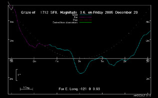 driven
up Wolf Ridge and am not sure it isn't gated down below. If I can go as far
as the pavement ends, I'll have a flat view to the horizon and the moon at the
cross on the topozone.com
map, where the ridge road goes from paved to dirt and may have a gate. This
spot is at 640 ft elevation and has a horizon of 1-2 degrees, well below the
moon at 5.5 degrees. Also, with the main action happening after mid-graze, the
altitude will be a tad higher. It's at track=0.59mi south. The hilltop another
mile on the dirt road is at track=0.49 south. This is still not ideal, missing
the best flat spots on the trailing side but clipping the top of the second
peak at least. The best spot is here,
at 0.21mi south, if the dirt road is accessible. Just as ideal, and almost certainly
accessible, is this
residential cul de sac above Sausalito at track=0.14 mi south, at 1000 ft
elevation.
driven
up Wolf Ridge and am not sure it isn't gated down below. If I can go as far
as the pavement ends, I'll have a flat view to the horizon and the moon at the
cross on the topozone.com
map, where the ridge road goes from paved to dirt and may have a gate. This
spot is at 640 ft elevation and has a horizon of 1-2 degrees, well below the
moon at 5.5 degrees. Also, with the main action happening after mid-graze, the
altitude will be a tad higher. It's at track=0.59mi south. The hilltop another
mile on the dirt road is at track=0.49 south. This is still not ideal, missing
the best flat spots on the trailing side but clipping the top of the second
peak at least. The best spot is here,
at 0.21mi south, if the dirt road is accessible. Just as ideal, and almost certainly
accessible, is this
residential cul de sac above Sausalito at track=0.14 mi south, at 1000 ft
elevation.
Spica
Christmas morning is the Spica graze - the most spectacular graze in terms
of brightness, moon, dark sky, for anywhere in 2005. The path goes from southwestern
Washington, across Oregon and eastern Nevada. I plan to try it from southeastern
Oregon. I'll have more later, but for now it looks like I'll be teaming up with
Derek Breit, who has put together his own page
on this graze. The lunar
profile from southeastern Oregon looks pretty nice near the edge of path
 driven
up Wolf Ridge and am not sure it isn't gated down below. If I can go as far
as the pavement ends, I'll have a flat view to the horizon and the moon at the
cross on the topozone.com
map, where the ridge road goes from paved to dirt and may have a gate. This
spot is at 640 ft elevation and has a horizon of 1-2 degrees, well below the
moon at 5.5 degrees. Also, with the main action happening after mid-graze, the
altitude will be a tad higher. It's at track=0.59mi south. The hilltop another
mile on the dirt road is at track=0.49 south. This is still not ideal, missing
the best flat spots on the trailing side but clipping the top of the second
peak at least. The best spot is here,
at 0.21mi south, if the dirt road is accessible. Just as ideal, and almost certainly
accessible, is this
residential cul de sac above Sausalito at track=0.14 mi south, at 1000 ft
elevation.
driven
up Wolf Ridge and am not sure it isn't gated down below. If I can go as far
as the pavement ends, I'll have a flat view to the horizon and the moon at the
cross on the topozone.com
map, where the ridge road goes from paved to dirt and may have a gate. This
spot is at 640 ft elevation and has a horizon of 1-2 degrees, well below the
moon at 5.5 degrees. Also, with the main action happening after mid-graze, the
altitude will be a tad higher. It's at track=0.59mi south. The hilltop another
mile on the dirt road is at track=0.49 south. This is still not ideal, missing
the best flat spots on the trailing side but clipping the top of the second
peak at least. The best spot is here,
at 0.21mi south, if the dirt road is accessible. Just as ideal, and almost certainly
accessible, is this
residential cul de sac above Sausalito at track=0.14 mi south, at 1000 ft
elevation.