A Quintessential Santa Cruz Mountain Cycling Adventure


For years back in the late 80's and 90's, the essential long ride for many of my triathlon tribe, was the Eureka Canyon Loop. Starting from town, I'd ride out to Corralitos, then up Eureka Canyon to the saddle at Buzzard Lagoon, onto Highland Way and westward along San Andreas Fault to the top of Old San Jose Rd, for a speedy ride down to Soquel. 42 miles and a good bit of climbing. After sufficient recovery from my hip surgery, I resumed this favorite - but not for long. Old San Jose Rd seems in the 12 year interrim, to have gotten busier, and with more type-A drivers who feel that my 40 mph on the bike isn't fast enough; because they can do maybe 45mph on this curvy downhill road. A few close calls and I resolved to never again ride that road in the downhill direction. The solution was obvious - continue onward past Old San Jose Rd on Summit Rd, to Hwy 17 and Mtn Charlie Rd, down to Scotts Valley. From there, I decided to go down Granite Creek Rd to Branciforte, then upward to Mtn View Road up to the ridge and St. Clares Retreat, down the other side to Castelegno's on Old San Jose Rd, and back down to town. 60 miles, 5,000 ft of climbing, and a great workout. I've done this ride now, here in 2012, most Saturday's that I have free for a long ride. I'm afraid I might soon burn out on it and look for something different, and so this day - Aug 18 - I decided I'd bring my new pocket Lumix camera and capture the key places along the way in photos.

I do most of my training rides alone, and my training runs alone as well. This is quality time for me to meditate on life. This ride is perfect for such.

Mile 0: my car in the parking structure at InShape gym. The adventure begins!

Mile 1: coming down to the Soquel Creek bridge. A nice mural beneath a pricey McMansion.

Mile 1: Capitola-by-the-Sea village. California girls, sand, surf, and the Big Sur mountains in the distant background.

Mile 3: Cabrillo College and the entrance to the dirt road to Cabrillo Observatory, where I spend much of my best moments on campus

Mile 3: Cabrillo College

Mile 5: The main entrance to The Forest of Nicene Marks State Park - the miles of historic and redwood-shaded narrow guage rail line (now running trails) with their consistent slope have made this one of the California's premier training Meccas, attracting world-class runners and pro mountain bikers as well. I've spent many a weekend day running and biking these trails.

Mile 5.5: I've been known, after my long runs (12-16 miles), to have such a (very rare!) hankering for red meat that after finishing, I run the next half mile to the Aptos St. BBQ. Their outdoor wood-fired BBQ cooks up excellent tri-tip sandwiches on sourdough.

Mile 7: primo blackberry bushes along Valencia Rd, heading now into the rural hills and redwoods.

Mile 8: If free blackberries are not to your liking, this self-serve Gravenstein apple stand has been here for decades. Take what you want, and pop your money into the box. If it were later in the ride, it'd be a welcome trade.

Mile 8: This unassuming curve in Valencia Road has a special meaning for me. I cannot pass this spot without remembering that it was right here, cycling in March of '97, that I felt the first little twinge that within weeks flared to become the loss of all cartilage in my left hip as early osteonecrosis took hold. Although it was just a small little ache noticed right here, somehow my body knew that this was a life-changing moment and burned the place and time into my memory.

Mile 14: After some hilly riding up and down Cox Rd, up Day Valley, Freedom, Hames, Pleasant Valley, and a long downhill, I arrive at the famous Corralitos Market - center of this little community and a favorite spot for cyclists and non-cyclists to indulge in the tastiest sausage anywhere.

Mile 16: Now follow some of the nicest scenery of the ride, several miles heading up past cabins and homesteads along Corralitos Creek into Eureka Canyon.

Mile 18: There are a number of retreats in the Santa Cruz Mountains, including Pema Osel Ling, up past the switchback after leaving Corralitos Creek. I heard Tibetan gongs as I passed.

Mile 20: An homage to Dave Wyman's great shots of blue roads and yellow centerlines. We're about to turn a curve and come to my favorite spot on the entire ride...

Mile 20: This is the largest of several streams coming steeply down from the ridge above along upper Eureka Canyon Rd. Last week I saw something here which brought the biggest smile I'd had in weeks - a little tree frog. Frogs have disappeared from the creek next to my downtown abode, and anywhere else in town, so far as I can hear. I just don't hear the chirping of frogs any more.

On this muggy day, the cold mountain stream felt great. I've been filling my water bottles here for 25 years. Notice that handsome bike in the background!

Mile 23: top o' the ride, at Buzzard Lagoon saddle. At this point, you've done nearly 3,000 ft of total climbing. Nicene Marks State Park begins not far up Buzzard Lagoon Rd, at its northeastern edge.

Mile 25: Camp Loma, often filled with excited kids; this week it's quiet. It's another opportunity to stop, have another bite out of my avo sandwich, and get as wet as I can with the cold water at the headwaters of Soquel Creek.

Mile 27: Highland Way at the top of Laguna Rd, where Karl lives

Another mile of rolling curves and Highland Way passes Spanish Ranch and Mt. Bache and becomes Summit Rd. Here is Radonich Ranch, site of the Skyland 10K which Ferrell and I ran last month Elevation here is about the same as Buzzard Lagoon.

Mile 30: Summit Store - a confab for cyclists ("confab" means "with fabulousness", for those the language challenged). This group rode this morning down from San Francisco, up Old San Jose Rd to the store, and will continue on north to Mountain View where they'll pick up the commuter train to take them back to SF. 125 miles - a solid Saturday ride.

Mile 35: I made it only halfway up the last 500 ft climb towards the Hwy 17 before having to knock on a door and beg for water! Muggy, muggy, muggy. A couple miles later, here we are at Hwy 17/Summit overpass. Elevation 1800 ft.


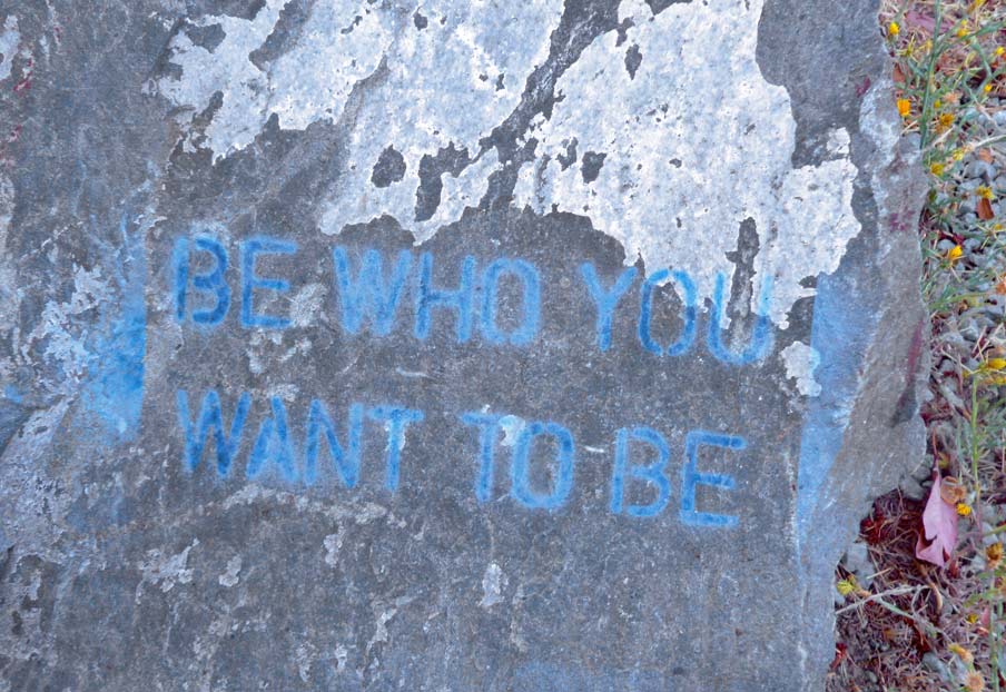
Mile 36: The top of Mtn. Charlie Rd. At the base of the monument (at right) is this rock with a Santa Cruzy message.

I can't imagine building this difficult road with hand tools for a promise of $6,000. Nowadays, you couldn't get a county inspector to come out and sign off on your work for that. Worse, the county eventually stiffed him and took his road for only $600, if you read the story here. The more things change, the more they stay the same, I suppose.

Rider's view of Mtn Charlie. It's got sections with sustained 16% grade, and is pretty rough. It's not a road given much loving attention since Hwy 17 went in many odd years ago. But, if you're willing to go slow, it's a beautiful road to go down. Redwoods, oaks, madrone, occasional cabins, and retreats built by Silicon Valley people.

It's a pretty trippy cycling road, as all Cruzers know.

Mile 41: We emerge onto Glenwood Drive. More redwoods and creeks and gentle downhill all the way into...

...Mile 43 and Scotts Valley. A dogleg to cross Hwy 17, then up a short hill, and then a great swooping downhill back into the redwoods along Granite Creek.

Mile 45: Here, the road flattens and I stop to enjoy the creek, take a last hit off my "5 hr Energy", another bite off my avo sandwich, and onward.

Mile 46...to Branciforte Rd. Left and upward past some tempting blackberry bushes which I resist.

Mile 49: the first maple leaves of the coming Fall, in Branciforte Creek, from a bridge.

Mile 50: begins the last real hill - Mtn View Rd is steep and tops out at St. Clares Retreat. The road becomes Laurel Glen with a great downhill towards...

Mile 54: Castelegno's store, where I have the last remnant of my avo sandwich. Yum!

I love the funky authenticity of Castelegno's! Hmph. Lost tortoise. How far could he have gotten?

Mile 58: Down Old San Jose Rd and back to town. The Ugly Mug in Soquel Village is my favorite WiFi work spot. Friendly staff, mostly locals here, great biscotti.

Mile 59: The old tressle over Soquel Creek at Capitola-by-the-Sea village.

Mile 59: Capitola Venetian. Party'rs and seabirds. We're a mile from the gym. And there you have it - my favorite training ride route of 2012.