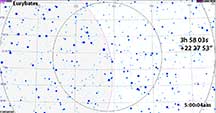
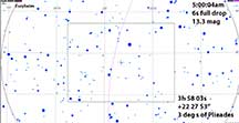
This high priority spacecraft destination Trojan asteroid Eurybates is occulting a 13.3 mag (combined) star on Wed morning through NorCal and Nevada and Az. The magnitude drop will be complete for us. There's a big effort to get as many occultation observations as possible to map the shape and refine the astrometry, and also search for other satellites. It has one known satellite but it's not expected to be visible for this path, apparently far far away, and it's only about 1-2 km across so would be very difficult to reliably record an occultation w/o a much bigger scope at high cadence. But the tenatively believed origin of the Trojan Asteroids suggests they may have more moonlets than perhaps other main belt asteroids, and especially since we know it has one already, it may have more that are too close to resolve even for HST (it's been imaged by HST and that's how the first satellite was discovered). Obviously essential to discover ANY satellites before the spacecraft gets there (remember the mayhem in "Star Wars" when Han Solo emerged from hyperspace arriving at Princess Leia's home planet after it had been blown to pieces!)
This is a special high-priority SWRI campaign object. The Lucy Mission - a space mission doing a tour of the Trojan Asteroids later this decade, has Eurybates as its most important target. It is the largest of its class and already has one known moon. It's important to improve the orbit, and to understand the topography and surrounding moon(s) before the mission planning is finalized. The object is entering the winter Milky Way and so perhaps there will be more events this observing season but so far I personally don't know of any.
The RECON telescope volunteers are mobilzed for this, but the difficult time-of-week (5am on a Wednesday) has caused trouble in insuring all tracks are manned. Also, weather is going to be hit and miss with cirrus clouds expected over much of CA and Nevada. The predicted path goes across Sacramento, Bridgeport, and into Nevada. The cloud forecast looks grim for the Central Valley Sacto and west of that, which had been my first thought to go to. But it is supposed to be clear just past the crest of the Sierras.
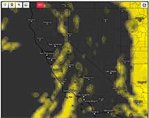
My personal tentative plan is to try for this event, hopefully with Kirk as co-pilot in my RAV4, by driving to the crest of the Sierras near Sonora Junction north of Bridgeport, after an exhausting drive after efficiently closing up my Astro 8A class perhaps a bit early on Tuesday evening. The drive time is expected to be 5.0 hours, so if we leave promptly at 10pm after meeting Kirk at my place after returning from Cabrillo, then we should arrive at our sites by 3:00am, and have both stations set up by 4:00 am and ready for the event. I'll trim Astro 8A time as needed to insure success, and of course we can pull over and get the event along the drive if necessary. The goal is to get over the crest of the Sierra so that skies will be better expected to be clear (as of the GFS maps downloaded Saturday afternoon, below). Then, to add appeal to do this, bring our photo gear and enjoy photographing the aspen in the Eastern Sierra from Sonora Junction down to at least Mono Lake and perhaps the June Lake loop, where I've taken some outstanding pictures in the past. Virginia Lakes and Lundy Lake and near Bridgeport, and also near Conway Summit have spectacular photo spots. The drive time to Mono City from My house is 5hr 5min late at night like right now as I do this on iPhone GoogleMaps. That's taking 108 as the route.
Track Lines descriptions for along Hwy 395
Oct 18, 5:00pm - Hwy 108, 4, 120 have all been closed going over the Sierra, after the snow dusting of yesterday, and the forecast of a wetter storm Tuesday evening. But currently Hwy 88 through Kirkwood and Carson Pass is still open. That makes getting to our sites a little over a 6 hour drive. The cloud maps still show a well defined clear band that is covering the Mono Lake area. Go/NoGo decision still not made. Weather is going against us here.
 |
 |
 |
 |
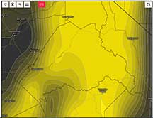
Newer Weather Forecasts Maps. The word from the experts is that the European model ECMWF is the most accurate, with the U.S. model GFS being a close second in accuracy, so I've plotted both here, as of Monday evening 9pm. The maps are for event time at 5am Wednesday morning. The best way to avoid road closures on Hwy 4, Hwy 120 and Hwy 108 is to go up Hwy 88 over Carson Pass and into Nevada to get to Hwy 395 and then head south. It's then 318 miles and 6hr 23 minutes at the requisite time of night, to get to Mono City from my home. Going around down through Tehachapi is much longer.
|
It looks like clouds hugging the Sierra Crest and spilling over the top. Our event targetis 60 degrees up in the SouthWest in the direction of the Sierra from Hwy 395. |
Total cloudiness is worse, for the ECMWF model, approaching 80% although driving out away from the Sierra along Hwy 167 could help. |
The GFS model is more optimistic, with pretty much clear skies |
Total clouds for GFS is again showing the crest of the Sierra as the problem so get away to the east. |
At the last possible decision moment - 7:00pm on Oct 19 Tuesday - the weather update showed a better ECMWF prediction, and still quite clear GFS prediction. AND, they re-opened Hwy 120 over Tioga Pass! I changed once again, made the decision to all systems "Go", after having already sent to Kirk a half hour earlier, the final decision to "Cancel". I did a short lab for my Astro 8A class (the photon escaping the sun illustrating mean free path concepts lab), and turned them loose at 8:20pm, got home by 8:33pm, madly threw everything into the car, Kirk arrived at 8:45pm and we were on the road by 9pm under totally cloudy skies as the 2nd storm in the series was arriving later. We made it through Hwy 120 w/o traffic trouble, through Yosemite w/o trouble despite lots of snow on the sides of the roads above 7,000 ft, and got to Hwy 395 near Lee Vining by 3:15am. We spent the next 45 minutes changing thoughts about sites, as the wind - instead of being about 6mph as predicted, was frequently gusting to nearer 20 mph and this would possibly ruin observations. We needed wind protection, and our planning idea to drive out east on Hwy 120 towards Benton Hot Springs would not provide that protection. Clouds were only about 20% of the sky, even here along Hwy 395. We decided to risk that it would stay this way through 5am's event. I had my car to help with the wind, but Kirk needed wind protection. We scouted Utility Road Cutoff, but too windy there on the edge of Lee Vining Canyon. Then tried places inside the residential neighborhood of Lee Vining, but Kirk was worried about arousing suspicions, and I finally decided to set him up at the parking lot of the Mono Lake Visitor's Center about a half mile north of town, off Hwy 395. I left him some bottles packed with boiling water (now just warm) to help keep the camcorder warm. Probably unnecessary, as tempertures felt in the mid '40's instead of the '30's. Then I headed north with the intent of getting a spot not on a claimed track, and somewhere in the tree protected area of the county park. Instead, I ended up at an old cemetery another mile along Cemetery Rd, east of the country park, where a row of trees looked promising. Not perfectly oriented as it turned out, but no more time to explore. The event was in 35 minutes. I got set up efficiently, clouds were maybe 30% of the sky and still promising optimism. The wind was there, but not howling. I thought I could survive it. I got it all set up with 15 minutes to spare, on target and tracking. Then the clouds suddenly started getting more numerous. Not cirrus, but mid-level clouds, thick enough to be opaque, and whitened by the full moon nearby. Clouds corresponded to "white out" on the video. I went back and forth between 8x and 16x. Only at 16x did I have consistent frame-to-frame easy visibility of the target and Kirk and I both settled at 16x.
Alas, the clouds built quickly, and Kirk was clouded out from the recording start at 11:59:51 till 12:00:20UT when he got some clear time till 12:00:56UT and cloudout after that. I was clouded out from the 11:58:02 start of my recording, until 11:59:31UT when it was in a clear spot, and stayed there until 11:59:52.3 which was within a couple of seconds of predicted "D" time. Then clouded out for the next minute. There's a chance I may have gotten the "D", but as of today, we don't know.
The Eastern NV crew had about 6 stations get the positive occultation, many others get misses or cloud outs. That's all I know for now. Here's my PyMovie light curves, and an image of the moment when the star MAY have been occulted, and you can see the cloud coming over as well...
|
RN: Image of PyMovie Screen. Look carefully inside the red box with the target. The yellow cross is precisely still on the target star, except it is missing. Several pixels away to the lower right of the center of that box's cross point, you can still see the fainter 13.5 magnitude companion star. Cloud is covering the right half of the image. |
RN PyMovie Light Curves: The brighter nearby tracking star lower left of the target (in blue), 13.3 mag target star (green) and empty sky (red) light curves during the interval of no cloud, and ending just after the image at left was captured. It looks like the green light curve on the target went to zero ~2 frames before the clouds occulted the nearer comparison star. I don't see how the clouds could have occculted the target w/o first occulting the comparison star, so it looks like the target was occulted by Eurybates just before the cloud got to it. |
Kirk's PyMovie light curve. Clouds ruined except for beginning 20 seconds after 12:00:00 UT, which was about 20 seconds after the event very likely ended. |
Nolthenius Position. Behind cypress trees in parking lot of cemetary on Cemetery Rd south of Hwy 167 and north of Mono Lake.
W. Long: 119 08 16.36
N. Lat 38 01 17.85"
Elev 1984 m
Track # 19.0 , uncorrected by me for any elevation correction, per directions by David Dunham.
Here are images I got by single frame stepping through my raw .avi video using LiMovie during the final seconds before the cloud out. The time stamps from the VTI are, in each case, from the last of the 8 identical frames of the each of the integration, for all images below. To get manually corrected times of the center of the integrations that correspond to these frames, I take the 2nd of the two time stamps, and subtract (0.03333 x 4) seconds. The frame rate is .03333 sec per frame for NTSC EIA. And 4, because there were 8 frames per integration and so exactly 4.0 frames of time from the end of the last frame will be the time of the center of the integration.
So who terminated the star first; the cloud, or Eurybates? It's not an easy tell... I will only have a more confident opinion once the timings from Eastern Nevada are plotted.
|
Integration #1 |
Integration #2 |
|
Integration #3 |
Integration #4 |
|
Integration #5. This is the last frame the target is clearly still there, but it looks like it's dimmed a bit relative to the neighbor. The center of this integration: 11:59:50.476, is essentially where Moore's PyOTE run assigned the time of the D |
Integration #6. Both target and neighbor are still there in proper position, but the target is now significantly the dimmer of the two. Dimmed tracking star (above the very bright star above "50". Time of the center of this integration is 11:59:50.743 |
|
Integration #7. Neighbor is there, target is not. The pixel with some brightness to neighbor's left is not in the right place. Compare with earlier images. UT of the center of this integration is 11:59:51.010 |
Integration #8. The target star looks gone to my eye, while the neighboring slightly fainter star is still there but blurred yet in proper position. Scintillation noise? Real D? |
|
Integration #9. Tracking star noticably dimmer than 1/2s earlier. Neither target nor neighbor are discernable, is there a vaguely brighter blur where the neighbor should be? |
Integration #10. Some hint of the neighbor, not for the target. |
|
Integration #11. No hint of either target or neighbor, tracking star definitely dimmer. Cloud prevents further views from here forward, until a full minute after the event, at about 12:01:02 when it briefly clears again. |
How I arrived at a corrected time for my "D" if it indeed occurred.
The existence of the neighboring slightly dimmer 13.5 magnitude star turned out to be a Godsend in this particular messy case of mine. Without it, I'd have little to go on as to whether I had a "cloud D" or a real D. As is, there's a case to be made it looks indeed to be real, if you read the comments and examine the images above.
The target star looks mostly gone on Integration #7, but is about the same brightness as the fainter 13th mag close neighbor on Integration #6. When there is a sharp D and the star goes from full on to full off, the software seems to take the time of last "full on" as the time of the D, in my experience. In this case, I estimate it should add another 30% of an integration to get to the D, since there's a hint of the target still on Integration #7, and none in Integration #8, when there is still a blurred image of the 13.5 mag neighbor yet it is deeper into the cloud than the target star. And, no hint where the yellow cross is centered on where the target star was. So, I take the time of the D as about 30% of the way from the central time of Integration #6 to Integration #7.
Does This Possible D fit with other Positives?
Observer Kai Getrost at E22 had a 6.2s event, longest of all observers we know of so far. From the Messner prediction page of long vs UT time, I find that if he was on E22 but at my longitude, his D would have been at 11:59:50.00 and his mid-occultation at 11:59:53.1. I was at E19.00, if I follow Dunham's advice and NOT do an altitude correction. If the E20 guess of 3s for his event was true, then my event would therefore likely be less than 3s, and my mid occultation at 11:59:53.1 would then mean that my D would be at or just after 11:59:51.6. However, the trend in other positives suggests strongly that this track E20 estimate of 3s was a guesstimated time from memory. The other times are suggestive of a properly roundish object with centerline at E22. If so, then at my station the occultation duration interpolates to 5.4s and so the inferred D, to be consistent, would be at 5.4/2=2.7s before 53.1 - 2.7 = 11:59:50.4 UT.
That's interesting! Because my own image stills (above) -determined visual judgment D was at 11:59:50.76. So - yes, this timing looks consistent with the others.
John Moore, IOTA observations coordinator, was kind enough to run my raw .avi file through PyMovie and PyOTE with his special knack, and finds indeed that my D above looks quite solid, and agrees very nicely with the other IOTA observers for which he has data. Also, that the E20 "3s" report was indeed just a guess and likely now to be too short a guess.
|
Numbers are occultation durations from the Slack conversation, and I was at E19.0. The trend looks like a fairly roundish object, with the exception of the "3s" duration at E20 That looks quite short compared to what one would expect from the other times. I have learned that it was, in fact a guess. I think that it's not unlikely and the actual duration there may be closer to 6s. |
John Moore's PyOTE light curve from my data. |
Preliminary sky plane, but just with IOTA observers who've already reported. |
===================================================================================
Other Astro- Related Photos...
|
Gas'ing up outside Groveland. I'd filled the gas tank before leaving. This was our first fill of trip-related gas. My final gas fill relevant for this trip was the morning of Oct 21 in Santa Cruz, after returning from the trip. |
Passing Tioga Entrance Station. No one's home! |
...which is just fine - we're on a mission here! |
I boiled water and poured it into containers and put into this cooler, in case we needed to keep our camcorders warm if temperature were in the 30's or lower. In fact, it was in the 40's and we had no equipment trouble. |
Charts! Also handy for showing the LA Power and Water engineer so he knew we weren't just vagrants camping on their land near Parker Creek. |
|
Kirk's station, we set it up quickly, behind a hedge in the parking lot of the Mono Lake Visitor Museum. |
Clouds are minimal - we're ahead of schedule a bit, and optimistic! We squandered a lot of time trying to find wind shelter we didn't anticipate we'd need though, but we still got data taking started on time. |
This is me, after the event, clouds visible, as is the Big Dipper behind me. I'm in the dirt parking lot behind a tall cypress tree (at right) to help with the wind, along Cemetery Rd at the old cemetery. |
Packed up and returned to Kirk's station, and dawn is beginning. |
There's bright Mercury through the clouds above Mono Lake. |
At this point, we had the LA Power and Water engineer find us, we had a long talk on water, climate... appreciated we were astronomers and science-philes and not trashers like he often finds out on their creek grounds. We had some pre-made breakfast, then spend the rest of the morning doing photography before heading to June Lake for lunch and to connect with the other observers at the RECON/ IOTA Eastern Nevada site.
 |
And... it starts raining hard. We decide it's time to begin thinking about getting back over the mountains before we get snowed in and it's too late. |
After lunch, we decided the weather was turning against us and if we were going to make it back across Tioga Pass before they closed it, maybe for good, we'd better get going NOW. We did hit rain coming down off Tioga Pass, but no snow, and occasional showers all the way back home. We stopped a few more times along the way for some high country photography, arrived home about 8:30pm. 24hrs start to end! Wow, it felt like a lot longer. An adventure!
My Fall colors photography page for photos on this trip...